-
E-mail
499578158@qq.com
-
Phone
13931875196
-
Address
Building 5, Rongzhi Technology Park, No. 123 Yuyuan Road, Luquan District, Shijiazhuang City, Hebei Province
Product Categories
Hebei Ziyue Machinery Equipment Co., Ltd
Volatile Organic Compounds Navigation Monitoring Vehicle
NegotiableUpdate on 02/09
- Model
- Nature of the Manufacturer
- Producers
- Product Category
- Place of Origin
Overview
The volatile organic compound monitoring vehicle consists of a vehicle body system, a sampling system, a meteorological system, a data collection system, a data analysis system, and a remote receiving system, etc., which meet the requirements of rapid response of measurement and management linkage and provide direction for environmental control.
Product Details
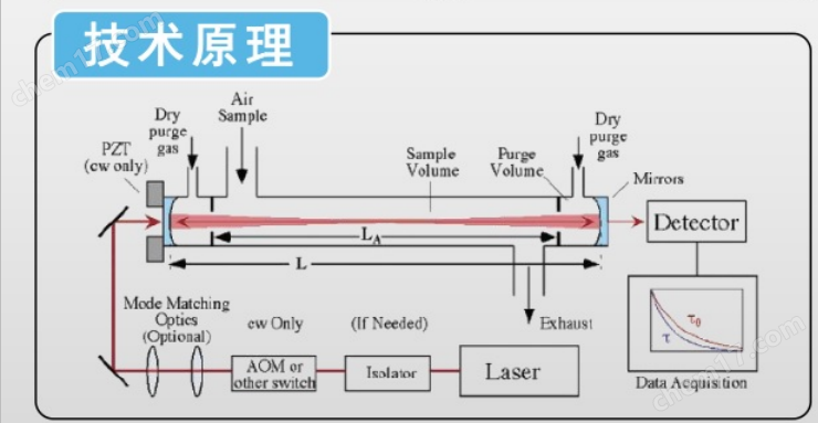
The volatile organic compound monitoring vehicle is an intelligent mobile monitoring platform that integrates high-precision analytical instruments, meteorological monitoring equipment, GPS positioning system, wireless communication module, and data processing platform. It is like a "mobile laboratory" that can perform real-time, continuous, and high spatiotemporal resolution rapid monitoring and traceability analysis of volatile organic compounds (VOCs) in the atmosphere along the way during normal vehicle operation.
1、 Meteorological parameter monitoring system
Real time measurement of key meteorological data such as wind speed, direction, temperature, humidity, and atmospheric pressure is the foundation of pollution traceability analysis. Wind direction data is particularly important for determining the direction of polluted air masses.
Positioning and Navigation System
High precision GPS/Beidou: Real time recording of vehicle location, driving speed, and trajectory, achieving precise binding of monitoring data with geographic location.
Inertial Navigation System (INS): Ensure positioning continuity when GPS signals are weak in tunnels or high-rise areas.
Data Collection and Processing Platform
Vehicle mounted industrial control computer: runs dedicated software to collect, process, and store data from various sensors in real-time.
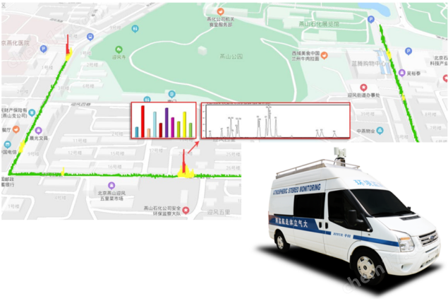
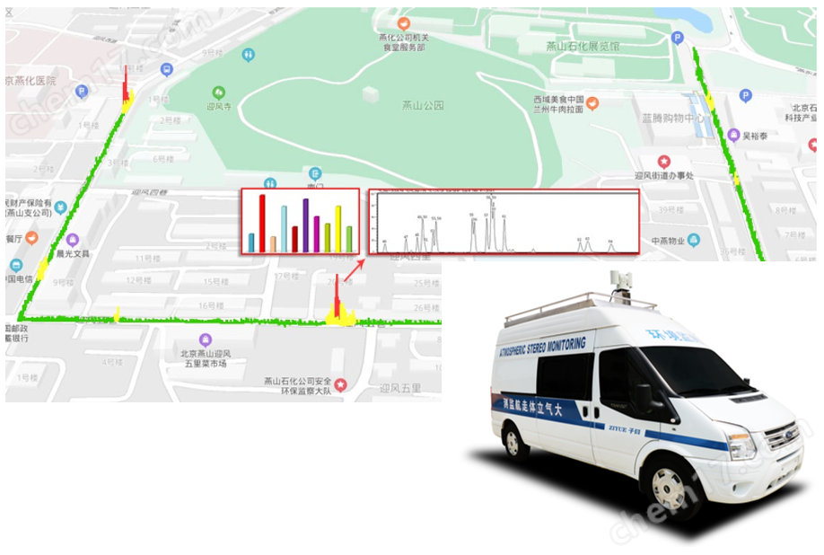
Data fusion and visualization: Integrating VOCs concentration, meteorological data, and vehicle trajectories to dynamically generate pollution concentration distribution maps on electronic maps, visually displaying high-value pollution areas.
2、 Working mode and technical characteristics
Navigation monitoring mode:
The system automatically collects data when the vehicle travels on a preset route or freely.
The data is presented in a three-dimensional form of "time space concentration" to generate a dynamic pollution distribution map.
Can quickly screen the VOCs pollution status in industrial parks, transportation arteries, and urban functional areas.
Fixed point monitoring mode:
Parking near suspected pollution sources, conducting long-term fixed-point monitoring, analyzing the temporal changes of pollutants, and assisting in confirming emission characteristics.
Emergency response mode:
After receiving complaints about odors or sudden accident alarms, quickly arrive at the scene, quickly identify the pollution range and characteristic pollutants, and provide decision support for emergency response.
This model uses a car as a mobile carrier and is equipped with various atmospheric detection related instruments such as VOCs atmospheric environment detectors and analysis and evaluation systems. Real time monitoring of VOCs and conventional air six parameters in the area through aerial monitoring. The whole vehicle consists of a body system, a sampling system, a meteorological system, a data aggregation system, a data analysis system, and a remote receiving system, which can detect sulfur dioxide, nitrogen dioxide PM2.5、PM10、 Multiple air monitoring factors such as carbon monoxide, hydrocarbons, benzene derivatives, aldehydes, ketones, phenols, lipids, and odorous organic sulfides are monitored on-site for fast and efficient monitoring. Connect the "monitoring" to "governance" joint, meet the requirements of rapid response of measurement and management linkage, and provide direction for environmental control. For example, conducting mobile monitoring of various key monitoring objects, cooperating with environmental law enforcement personnel for on-site law enforcement monitoring, and conducting environmental monitoring.
Navigation monitoring software
The software part has automatic control, data collection, data analysis, and automatic fault diagnosis functions, which can be automatically upgraded and updated. It has GIS map function, navigation and material concentration distribution trajectory map function.


Schematic diagram of navigation monitoring process
(1) Through on-site investigation in the early stage, confirm the main monitoring substances for navigation, select analytical instruments that meet the monitoring capability requirements, and choose a navigation monitoring plan.
(2) Based on the principle of fast cruising speed of the vehicle, it is possible to quickly navigate around the target park/area in the early stage to provide a regional VOCs' image 'and obtain approximate pollutant characteristics and problem point distribution.
(3) In the subsequent navigation process, design precise navigation routes based on the preliminary results, 'avoid taking the wrong path', and conduct repeated inspections on key locations. When sailing, count the instrument response time before moving forward until one or more concentration peaks are locked in the area. Record the signal strength of high point concentration, the number of minutes of flight, geographic location, wind direction, and wind speed information at that time.

Similar Product Recommend