-
E-mail
info@2ceco.com.cn
-
Phone
13691369094
-
Address
20H, Block A, Chengming Building, No. 2 Xizhimen South Street, Xicheng District, Beijing
Product Categories
Beijing Xiawei Shengtai Technology Co., Ltd
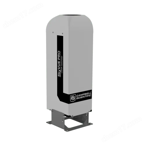
SkyVUE PRO LiDAR Altimeter
NegotiableUpdate on 02/04
- Model
- Nature of the Manufacturer
- Producers
- Product Category
- Place of Origin
Overview
The SkyVUE PRO LiDAR altimeter measures cloud height and vertical visibility, suitable for meteorological and aviation fields. It is an ideal product for long-term scientific research applications that require high levels of detail.
Product Details

SkyVUE PRO LiDAR AltimeterMeasuring cloud height and vertical visibility, suitable for meteorology and aviation fields, is an ideal product for long-term scientific research applications that require high details.
It has a sturdy structure, is suitable for long-term installation as it requires minimal maintenance, and has a layered cloud calibration program that allows for on-site calibration of the cloud altimeter.
SkyVUE PRO LiDAR AltimeterMeasuring cloud height and vertical visibility, suitable for meteorology and aviation fields, is an ideal product for long-term scientific research applications that require high details.
Complies with the guidance and analysis of the International Civil Aviation Organization and the World Meteorological Organization, including CAP437, CAP670, and CAP746.
SkyVUETM PRO's measurement report range is 10 kilometers, easy to use, and features * signal processing and optical design to provide resolution and performance.
SkyVUETM PRO has many standard features, from a tilt base and dual axis inclinometer for automatic cloud height correction to heaters, hair dryers, and sun filters for operation under all conditions, which can be used around the world.
The standard features include easy-to-use layer cloud calibration, long-lasting backup batteries, and dual clocks to enhance its many continuous diagnostic self check functions, ensuring continuous, reliable, and accurate performance.
Advantages and Characteristics
u A single lens design with high signal-to-noise ratio, maximizing detection sensitivity and maintaining higher performance at any altitude
u High performance, high specifications, and very competitive price
u The tilt angle can reach 24Improve the performance of precipitation conditions and reduce the impact of direct sunlight
u Two built-in clocks are continuously compared to ensure reliable operation of the device
u Mixing layer setting options applied in the field of air quality
u Easy to operate layer cloud calibration function, user-friendly standard calibration components, convenient for field calibration
Technical Introduction
SkyVUETMPROLidar cloud height meter measures cloud height and vertical visibility, suitable for meteorological and aviation fields. It is an ideal product for long-term scientific research applications that require high details. Using laser radar (light detection and ranging) technology, the instrument emits fast, low-power laser pulses into the atmosphere to detect the scattered signals of clouds and aerosols returning from above the instrument.
Adopting a high-efficiency single lens design to improve the optical signal-to-noise ratio allows for the integration of larger optical components in a compact design, thereby enhancing measurement accuracy and performance, while protecting the optical components from direct sunlight damage.
This method, combined with top-notch electronic components, provides a powerful and stable platform for measuring cloud height and vertical visibility with high accuracy. Even under the harshest conditions,SkyVUETMPROIt can also have excellent stability and repeatability in measurement, demonstrating outstanding performance.
SkyVUETMPROCan provide a range of10Kilometer cloud height and sky condition (most 5 level)Raw data on vertical visibility and backscatter distribution.
In air quality applications, an automatic mixing layer can be provided(MLH)Data options. The mixing layer is a very important parameter in air quality and air pollution models. The mixed layer is based on HNMIThe iterative algorithm used by the institution can measure the upper edge of the boundary layer.
SkyVUETMPRORunning this algorithm independently will integrate the results into the data information. This facilitates the integration of mixed layer data into any system currently in use, without the need for external specialized software. If you need a mixed layer option, please contact us.
Having a special ability to calibrate cumulus clouds, users can use simple and friendly on-site methods to measure and calibrate scattering coefficients, ensuring reliable scattering parameters without the need to send the equipment back to the manufacturer for calibration.
Cross check two internally separated quartz watches to eliminate unknown errors caused by clock drift and better ensure data reliability.
SkyVUETMPROCan tilt at different angles (maximum)24°). A small angle tilt can prevent damage from the high-intensity reflection of raindrops and frozen particles. In addition, it can also improve the sliding of rainwater on the cloud altimeter lens, which has better performance compared to a vertical cloud altimeter.
most 24°The tilted setup indicates that data loss caused by sunlight entering the lens can be avoided regardless of its use around the world. The internal dual axis inclinometer provides automatic correction of cloud height at all angles, ensuring easy installation and automatic calibration of cloud height during its service life.
Data visualization software
The cloud altimeter can be used CampbellofViewpointSoftware display,It can also be directly integrated into existing data systems.ViewpointThe cloud altimeter data output displayed by the software is both convenient and configurable, including information on weather conditions, mixing layers, and scattering data. All data comes with intervals and time ranges, which can be displayed simultaneously or separately.
Technical Specifications
instrument performance
Measurement range:0-10 km/33,000 ftminimum
Resolution:5 m/16.4 ft
Target range accuracy:±0.25%±4.6 m
Measurement cycle:2 to 600 s
Clouds: Maximum Measurement 4 layer
Sky state: According to WMO's requirements for SYNOP and METAR codes are divided into 5 levels
Vertical visibility: Report when there are no clouds
Laser wavelength912 nm±5 nm
Eye safety protection standards:Class 1M
Mechanical Specifications
Dimensions (including base):100 x 32.7 x 28.1 cm (39.4 x 12.9 x 11.1 in)with base
Shipping size:120 x 45 x 45 cm (47.2 x 17.7 x 17.7 in)
Weight:32 kg (71 lb)Excluding cables
Shipping weight:58 kg (127.9 lb)
Electrical specifications
Power Supply:110,115,230 VAC ±10%,50-60 Hz, the largest470 W
Battery: Internal 12 VDC, 2 AhBackup battery (in major measurement failure events, do not turn on the blower)/Heating, can provide2Hour by hour measurement
Interface:
dataRS-232 / RS-422 / RS-485 /Ethernet options
maintain:USB 2.0 (USB 1.1compatible)
Baud rate300-115200 bps
Laser safety standards:EN 60825-1:2001
Electronic security standards:EN 61010-1
environmental parameters
Working temperature range:-40 ℃to +60 ℃ (-40 ℉to +140 ℉)Battery not included
-20 ℃to +50 ℃ (-4 ℉to +122 ℉)Including standard batteries
Humidity range:0-100% RH
Maximum wind speed:55 m/s
Waterproof ratingIP66 (NEMA 4x)