-
E-mail
406909520@qq.com
-
Phone
17312275363
-
Address
Mingfa Science and Technology Innovation Headquarters Base, No. 5 Pudong North Road, Pukou District, Nanjing City
Nanjing Weixin Space Information Technology Co., Ltd
Dry goods | Working principle and application scope of deepwater multibeam depth measurement system
Date: 2025-11-27Read: 0
Deep water multibeam depth measurement systemIt is a high-resolution underwater terrain measurement technology that can quickly obtain high-precision and fully covered underwater terrain data by emitting wide sector sound waves and receiving multipath echoes. Compared to traditional single beam depth measurement (which can only obtain discrete point water depth along the trajectory), the core advantage of multi beam depth measurement isStrip based synchronous measurementEspecially suitable for deep-sea exploration in large and complex terrains. The following will explain the working principle and application scope.
1、 Working principle: From sound wave emission to terrain inversion
The core of the multi beam depth measurement system is to use "array transducer+beamforming technology" to convert a single transmission pulse into multiple narrow beams covering a certain sector, and then calculate the water depth and position of each beam footprint through echo delay and intensity, and finally concatenate them into continuous seabed terrain. The workflow can be divided into the following key steps:
1. Hardware composition
The system is mainly composed ofTransducer array, data acquisition unit, motion sensor (attitude/positioning), processing softwareComposed of four parts:
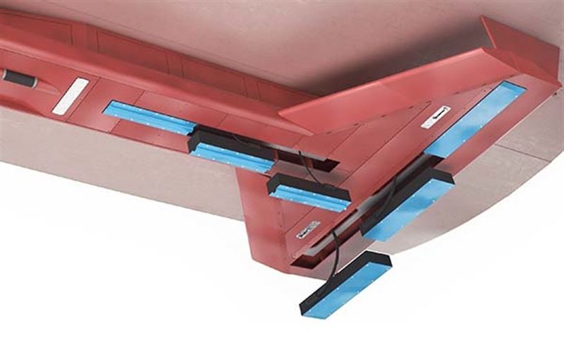
Transducer arrayUsually installed on the bottom of the ship or trailer, integrating transmission and reception functions. The launch array is responsible for emitting high-frequency sound waves to the seabed (frequency adjusted with water depth, commonly 12kHz~50kHz in deep water); The receiving array consists of dozens to hundreds of elements and is used to receive echoes reflected from the seabed.
motion sensorIncluding GNSS (Global Navigation Satellite System) providing absolute position, Inertial Measurement Unit (IMU) monitoring ship attitude (roll, pitch, heave), and Acoustic Doppler Current Profiler (ADCP) assisting in speed measurement to ensure data spatial positioning accuracy.
Data processing unitReal time collection of sound wave signals, attitude, and positioning data, and generation of water depth point clouds through algorithms.
2. Core workflow
Acoustic emission and beamformingThe transducer emits a wide sector (such as 120 °~160 °) of sound wave pulses ("pencil beam" or "fan-shaped beam"). Receiving array passedPhased array technologyDecompose the echo of a wide sector into tens to thousands of narrow beams (with an angular resolution of 0.1 °~1 °) by controlling the phase difference of each array element, covering the receiving sector symmetrical to the transmitting sector (such as 150 ° × 150 °).
Echo detection and water depth calculationThe echo delay (Δ t) of each beam corresponds to the time it takes for the sound wave to travel back and forth to the seabed. Combined with the Sound Velocity Profile (SVP), which requires advance or synchronous measurement of seawater temperature, salinity, and pressure to correct the sound velocity, the water depth of the beam footprint is calculated
D=2c ⋅ Δ t+attitude/installation deviation correction
Among them, c is the speed of sound, and Δ t is the echo delay.
Position and attitude correctionDue to roll, pitch, heave, and GNSS positioning errors during ship navigation, it is necessary to dynamically correct the horizontal position (X, Y) and vertical depth (Z) of the beam footprint through IMU data to ensure terrain stitching accuracy.
Strip splicing and mappingThe beam footprints of consecutive voyages are sorted by time/position, removing noise points (such as fish schools and bubble interference), and finally generating high-resolution seabed DEM (digital elevation model) or 3D topographic map.
2、 The particularity of deepwater scenes
In deep water environments (usually>1000m, even above 10000m), multi beam systems face challengesStrong attenuation of sound waves, long propagation time, and complex environmental noiseWaiting for challenges, therefore the system design needs to be optimized with targeted optimization:
Low frequency emissionChoose lower frequency sound waves (such as 12kHz~30kHz) for deep water to reduce attenuation (sound energy is inversely proportional to the square of frequency) and ensure effective reception of echoes.
High power transmissionIncrease the transmission power (several kilowatts to tens of kilowatts) to compensate for the loss of sound energy during long-distance propagation.
High precision sound speed correctionDeep sea sound velocity is significantly affected by vertical stratification of temperature and salinity (such as thermocline and salinity), and needs to be measured in real-time using SVP or CTD (temperature salinity depth gauge) to avoid depth measurement errors caused by sound line bending (deep water errors may reach several meters).
Equipped with a trailer or AUVTo avoid the inconvenience of ship platforms in deep-sea operations (such as power and stability), multi beam systems are often integrated into autonomous underwater vehicles (AUVs), remotely operated unmanned vehicles (ROVs), or specialized towed vehicles to achieve flexible detection.
3、 Application scope: From marine science to engineering practice
The multibeam depth measurement system is the "eye" of deep-sea exploration, widely used in fields such as marine resource development, scientific research, and national defense security
1. Marine Geology and Earth Science Research
Submarine topographic mappingDraw micro terrains such as seamounts, trenches, mid ocean ridges, and hydrothermal zones to reveal geological processes such as plate movement (such as subduction zone accretion wedges) and volcanic activity (such as ocean floor volcanic chains). For example, using multiple beams to discover ultra deep sea terraces in the Mariana Trench, or providing topographic evidence for IODP (International Ocean Discovery Program) drilling site selection.
Sedimentary environment analysisIdentifying sedimentary types (turbidity currents, iso deep currents) and paleoclimatic records through underwater micro landforms (such as sand waves, scour troughs, mud volcanoes) to assist in reconstructing ancient marine environments.
2. Exploration and development of marine resources
Oil and gas resource investigationDetecting structures such as continental shelf edges and basin depressions (such as faults and folds), and delineating the cap rocks and reservoir spaces of oil and gas reservoirs; Monitor the well location terrain of the drilling platform to ensure operational safety.
Mineral Resource AssessmentIdentify the distribution areas of polymetallic nodules, cobalt rich crusts, and hydrothermal sulfide deposits (such as the Pacific Ocean's Clarion Clipperton Zone) and assess resource reserves.
Renewable energy developmentPlan the site selection for offshore wind farm pile foundations (avoiding trenches and cliffs), monitor the routing terrain of submarine cables/pipelines, and reduce erosion risks.
3. Marine Engineering and Environmental Monitoring
Channel and Port ConstructionSurveying and mapping the navigation obstacles, reefs, and shallow waters in port waters and waterways (such as deep-water channels) to ensure the safety of large ships' navigation; Monitor the terrain changes after dredging projects.
Maintenance of submarine pipelines/optical cablesInspect the exposed, suspended, or buried status of pipelines (identify terrain changes through multi beam recognition) to prevent fracture accidents.
disaster warningMonitor submarine landslides (such as continental slope instability) and tsunami source terrain (such as tsunami ridges) to assess their potential threats to the coast.
4. Defense and security field
Underwater target detectionAssist in searching for lost submarines, sunken ships, or mines, and improve positioning accuracy through terrain matching.
Military terrain supportProvide high-precision underwater terrain data for submarine covert navigation and landing site selection.
summary
Deep water multibeam depth measurement systemThrough the technical route of "wide sector transmission multi beam reception multi-source data fusion", efficient and high-precision mapping of deep-sea terrain has been achieved, which is a tool for modern ocean exploration. With the miniaturization of AUV/ROV platforms and the introduction of AI algorithms such as automatic noise suppression and terrain feature extraction, their value in deep-sea scientific research and engineering applications will be further highlighted.