-
E-mail
lina-he@zolix.com.cn
-
Phone
13810146393
-
Address
Feihong Road, Nanhu Avenue, Liangxi District, Wuxi City, Jiangsu Province
Jiangsu Shuangli Hepu Technology Co., Ltd
Which industries require airborne shortwave infrared hyperspectral technology? How to choose domestic instruments?
Date: 2025-11-17Read: 1
When traditional remote sensing technology is difficult to penetrate surface artifacts and accurately identify material components, airborne shortwave infrared hyperspectral technology is becoming the "perspective eye" in geological exploration, environmental monitoring, precision agriculture and other fields with the core advantage of "integrating spectra".
1、 Selection Guide: Four Core Dimensions, Accurately Matching Application Requirements
The selection of airborne shortwave infrared hyperspectral systems should take into account both technical parameters and practical application scenarios, avoiding blind pursuit of "high indicators" and neglecting adaptability. The core selection dimensions are as follows:
1. Spectral performance: matching material identification requirements
·Spectral range: If focusing on geological exploration and mineral identification, products with 1000-2400nm full shortwave infrared coverage should be selected to fully capture the characteristic absorption peaks of minerals; If both agriculture and environmental monitoring are taken into account, the 400-1700nm visible near infrared+short wave infrared composite band (such as the GaiaSky series of Shuangli He spectrum) can be selected.
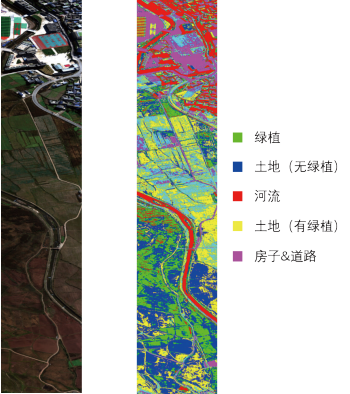

400-1000nm band camera classification and recognition results 900-1700nm band camera classification and recognition results
·Spectral resolution: The accuracy of material identification directly depends on spectral resolution. For fine geological exploration, it is required to be ≥ 2.5nm, while for routine environmental monitoring, 3.5-5nm can be selected.
·Number of spectral channels: The more channels there are, the more continuous the spectral curve becomes. The GaiaSky-mini3-VN series of dual benefit spectra can have up to 1024 channels, ensuring no missing spectral information.
2. Imaging and Platform Adaptation: Balancing Efficiency and Stability
·Spatial resolution: When flying at an altitude of 300 meters, ground sampling distance (GSD) ≤ 0.15m can meet the requirements of fine monitoring.
·Scanning speed: High frame rate products such as GaiaSky-mini3-VN from Shuangli HePu are required for large-area surveying, which can significantly improve operational efficiency; Fixed wing drones need to be adapted to external push scan mode, while rotary wing drones can choose hover shooting mode.
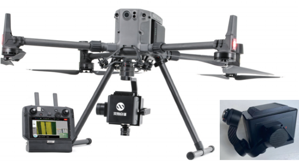
GaiaSky-mini3 third-generation unmanned aerial vehicle hyperspectral imaging system
·Platform compatibility: Lightweight design is key. Choosing a system with a weight of ≤ 1.5kg (such as the GaiaSky mini series weighing only 1-1.2kg) can adapt to mainstream drones such as DJI M300 and Zongheng CW-100, reducing the threshold for installation.
3. Data processing: ensuring accurate and efficient results
·Calibration capability: It is necessary to support the full process calibration of spectra, radiance, reflectivity, geometric precision correction, etc. The calibration software independently developed by Shuanglihe Spectrum has multiple advanced algorithms built-in, which can achieve image stitching of any area to ensure data accuracy.
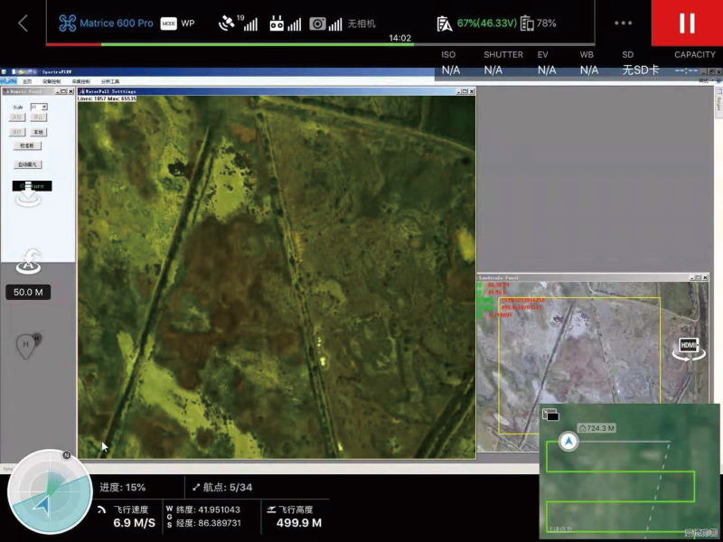
Double benefit spectrum Gaiasky-mini2-VN acquisition and control interface
·Real time performance: Emergency monitoring requires the selection of a system that supports real-time data transmission and inversion, which can output real-time results such as vegetation index and water quality parameters, providing quick support for decision-making.
·Software compatibility: The data format needs to be compatible with third-party software such as ENVI and Matlab, and support custom inversion model input to meet the needs of scientific research and industry customization.
4. Environmental adaptability: Dealing with complex working conditions
·Extreme environments (high altitude, high temperature difference, strong vibration) require the selection of products that have been tested and verified.
·The recommended protection level is ≥ IP54 to ensure normal operation in adverse weather conditions such as rainy days and sandstorms.
2、 Application areas: Technology implementation, unlocking precise solutions for multiple industries
The Shuangli Hepu airborne shortwave infrared hyperspectral system, with its advantages of "wide range, non-contact, and high precision", has achieved mature applications in multiple core fields and become a key support for industry upgrading
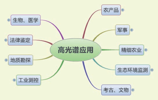
Application association
1. Geological Exploration: Efficient Mineral Exploration and Geological Mapping
The shortwave infrared band can accurately identify the characteristic spectra of clay minerals, carbonates, sulfates and other altered minerals, and achieve large-scale mineral mapping and delineation of prospecting target areas through airborne hyperspectral data. The dual benefit spectral system can quickly invert mineral distribution patterns, analyze diagenetic and ore-forming processes, and has been applied in exploration projects such as porphyry deposits and rare earth deposits.
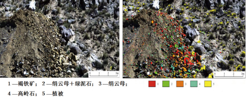
Mineral identification in mining areas
2. Environmental monitoring: comprehensive ecological protection
Water monitoring: It can quickly identify water quality parameters such as oil spills, microplastic pollution, chlorophyll content, total nitrogen and total phosphorus. Through real-time inversion of normalized water index (NDWI), water stress index (MSI), etc., it can achieve full coverage monitoring of rivers and lakes, providing scientific basis for water pollution tracing.
Soil and vegetation monitoring: Accurately invert soil moisture content, heavy metal content, organic matter distribution, as well as vegetation chlorophyll content, nitrogen, phosphorus, and potassium levels, and the degree of pest and disease stress, supporting agricultural irrigation optimization, soil remediation assessment, and ecological diversity investigation.
Disaster emergency response: After earthquakes, floods and other disasters, the extent of vegetation damage and soil erosion can be quickly assessed, providing data support for disaster relief deployment and post disaster reconstruction.
3. Precision Agriculture: Empowering Smart Production
By capturing the spectral response differences of crops in the short wave infrared band, early warning of disease and pest outbreaks can be given, and crop nutrient deficiency types (nitrogen/phosphorus/potassium) can be accurately distinguished. The Shuangli Hepu system supports real-time calculation of more than 20 vegetation indices, and users can customize analysis models to achieve "on-demand fertilization and precise pesticide application", reducing agricultural inputs while improving crop yield and quality.
Its lightweight design is suitable for small rotary wing drones, which can meet the needs of small-scale fine monitoring and large-scale field operations in greenhouses, orchards, and other areas.
4. Military and Security: Pseudo identification and target detection
Shortwave infrared can penetrate traditional optical pseudo networks and vegetation pseudo networks, accurately identifying spectral differences between pseudo targets and backgrounds.
The Shuangli Spectrum System, with its high-sensitivity detector and fast imaging capability, can achieve battlefield pseudo target recognition, military equipment detection, and sensitive area security monitoring, providing technical support for national defense and public safety.
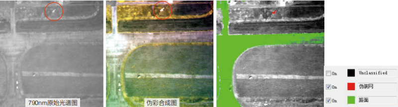
790nm original spectrum/pseudocolor synthesized image/recognition result
3、 Recommended core products of Shuangli Hepu: Technological accumulation, forging standards*
Relying on more than ten years of hyperspectral technology accumulation, Shuangli Hepu has formed a product matrix of "full scene coverage+customized services". Several core airborne shortwave infrared hyperspectral systems accurately match different application needs:
GaiaSky series airborne hyperspectral imaging system (GaiaSky-mini2/3-VN/NIR+POS)
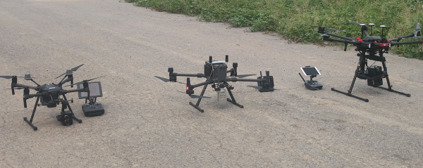
GaiaSky series products
UV |
VIS |
VNIR |
NIR |
SWIR |
MWIR |
LWIR |
Evidence collection: fingerprints, fake* |
color |
fruits and vegetables |
plastic |
pharmaceutical |
Hot gas |
mineral |
semiconductor |
picture |
maturity |
sorting |
mineral |
Water temperature |
Shuangli Hepu always takes "independent research and development+scene landing" as its core, deeply integrating grating splitting and detector technology with industry needs. Its airborne shortwave infrared hyperspectral system not only has the national leading technical indicators, but also has been verified to be stable and reliable through more than a thousand actual projects.