-
E-mail
406909520@qq.com
-
Phone
17312275363
-
Address
Mingfa Science and Technology Innovation Headquarters Base, No. 5 Pudong North Road, Pukou District, Nanjing City
Product Categories
Nanjing Weixin Space Information Technology Co., Ltd
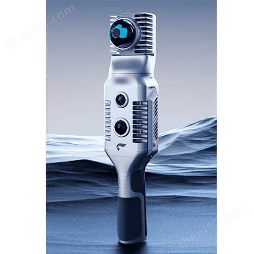
SLAM2000 handheld LiDAR scanner
NegotiableUpdate on 01/27
- Model
- Nature of the Manufacturer
- Producers
- Product Category
- Place of Origin
Overview
The SLAM2000 handheld LiDAR scanner, equipped with Pegasus industry grade SLAM algorithm, truly achieves ultra comfortable scene adaptation and high-precision scanning and rapid construction, providing efficient and accurate solutions for 3D mobile measurement needs.
Product Details
SLAM2000 handheld LiDAR scannerAdopting a hemispherical non repeating scanning laser sensor, combined with a rotating pan tilt, can achieve 720 ° wu blind spot point cloud coverage;
Adding a visual camera and introducing the visual SLAM algorithm can effectively improve the adaptability of 3D reconstruction for weak structural feature scenes;
Equipped with Pegasus industry level SLAM algorithm, it truly achieves super free scene adaptation and high-precision real-time scanning and rapid construction,Provide efficient and accurate solutions for 3D mobile measurement needs.
The laser field of view angle of 360 ° horizontal rotating pan tilt combined with the 360 ° × 59 ° field of view angle of the laser sensor can form a panoramic laser field of view angle.
KPTS/s non repetitive scanning, 70m measuring range, 200kHz point frequency, random distance measurement error of 2cm, laser safety level Class 1.
The high-precision inertial odometer has better control performance for special scenarios.
SLAM2000 handheld LiDAR scanner:512 GB
512GB built-in SSD storage disk for more stable data storage.
The high-performance computing core can perform real-time SLAM mapping and output data results after data collection is completed.
Self developed inertial navigation chip
Thanks to its self-developed high-precision inertial navigation chip, SLAM2000 can effectively suppress cumulative errors in data acquisition; The fully optimized radar calibration algorithm and continuously upgraded industry SLAM algorithm ensure that SLAM2000 can quickly output high-precision 3D results in various application scenarios.
real-time mapping
The SLAM2000, equipped with a high-performance computing core, can construct maps during the data collection process and directly output the result data after data collection is completed, that is, real-time mapping, which can greatly improve the application scenarios with high timeliness requirements such as emergency rescue.
extension module
SLAM2000 has multiple external interfaces such as Type-C and aviation plug, and can be connected to external power sources S-RTK100、 Backpack and other extension modules to meet users' more application needs.
The SLAM2000 uses a safer 3000mAh replaceable smart battery handle, which ensures continuous and stable operation for 95 minutes. The charging adopts Type-C interface and comes standard with 65W fast charging equipment to ensure the power supply of SALM2000.
Battery replaceable
3000mAh
Standard fast charging
Supporting software, worry free calculation
SLAM2000 comes standard with SLAM GO APP software and SLAM GO POST data calculation software. Combined with industry level SLAM algorithm, it can achieve high-precision point cloud output, coordinate conversion, point cloud coloring, etc. with just one click. Through the mobile app, device operating parameters can be queried, real-time mapping results can be previewed, and device firmware upgrades and maintenance can be performed.
Application field

Similar Product Recommend