-
E-mail
wangyingying@yunjingtianhe.com
-
Phone
13276363312
-
Address
Weifang Optoelectronic Industry Accelerator
Download
Shandong Tianhe Environmental Technology Co., Ltd
River water level monitoring station helps flood prevention: efficiently transmitting water level information, enhancing regional flood prevention, control and disaster reduction capabilities
Date: 2025-12-16Read: 0
River water level monitoring station assists in flood prevention: efficiently transmitting water level information, enhancing regional flood prevention, flood control and disaster reduction capabilities. [Model recommendation: TH-SW1, IoT integrated device, customized service supported by Yunjing Tianhe]In the emergency battlefield of flood prevention and control, changes in river water level directly affect the safety of life and property of coastal residents and the stability of urban operation. Traditional manual patrols are often difficult to cope with the rapid rise of sudden floods due to poor timeliness and limited coverage. The river water level monitoring station integrates high-precision radar or pressure type water level sensors, combined with IoT communication technology, to build an intelligent perception network covering the entire basin: the sensors capture water level fluctuations in real time, and the data is encrypted by wireless transmission modules and synchronized to the flood control command platform within seconds through 4G/5G or Beidou satellite channels, ensuring that management personnelMaster the water level dynamics of the river at the first time. When the water level exceeds the warning threshold, the system automatically triggers a multi-level alarm mechanism, notifying coastal residents to transfer, start pump station drainage, or close gates for interception through SMS, APP push, or sound and light warnings. This closed-loop management mode of "real-time perception intelligent warning rapid response" not only significantly shortens the information transmission chain, but also reduces the losses of flood disasters through precise scheduling of flood control engineering facilities, providing solid technical support for regional flood control and disaster reduction.
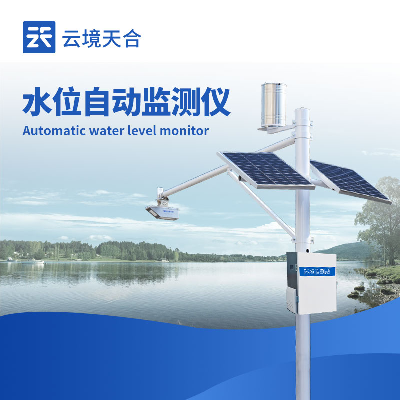
1、 Product Overview
SW1 is a fully automatic hydrological online monitoring system based on microwave technology, which can simultaneously measure the water level in the channel. It adopts K-band planar radar technology to measure the water level of the water body in a non-contact manner. According to the built-in software algorithm, it calculates and outputs real-time datawater level dataCan be used for non-contact flow measurement in rivers, irrigation channels, underground drainage networks, flood prevention warnings, and other occasions; This product has the characteristics of low power consumption, compact size, high reliability, and easy maintenance; The measurement process is not affected by factors such as temperature, sediment, river pollutants, and floating debris on the water surface.
2、 Application Fields
1. Water level measurement of rivers, lakes, tides, reservoir gates, underground water pipe networks, irrigation canals and canals.
2. Auxiliary water treatment operations, such as urban water supply, sewage monitoring, etc.
3. Flow calculation, monitoring of inflow and outflow flow, etc.
3、 Product Features
1. Non contact measurement, combined with cross-sectional parameters to calculate flow rate, not affected by wind, temperature, haze, sediment, floating debris, etc.
2. It is suitable for various measuring conditions, free from corrosion and foam, and can outputwater levelMeasurement data.
3. The water level adopts a planar array radar antenna with built-in angle measurement function. The device is compact in size and easy to install.
4. Convenient configuration software that can easily configure parameters according to actual needs to adapt to different usage conditions.
5. Not affected by changes in water vapor, temperature, and pressure in the atmosphere
4、 Monitoring platform
1. CS architecture software platform, supporting direct observation through mobile and PC browsers without the need for additional software installation.
2. Support multi account and multi device login
3. Support real-time data display and historical data display dashboard
4. Cloud servers and cloud data storage are stable, reliable, easy to scale, and load balanced.
5. Support SMS alarm and threshold setting
6. Support map display and viewing device information.
7. Support data curve analysis
8. Support data export in tabular format
9. Support data forwarding, HJ-212 protocol, TCP forwarding, HTTP protocol, etc.
10. Support data post-processing function
11. Support external running of JavaScript scripts
5、 Summary indicators
Power supply voltage: 100mA (working), < 1mA (sleeping);
Working voltage: 12V power supply
Operating temperature: -35 ℃~60 ℃;
Storage temperature: -40 ℃~60 ℃;
Outdoor protection level: IP68
Signal output: RS485/MODBUS protocol;
6、 Technical parameters
Water level measurement
Distance measurement range: 0.1-40rice
Distance measurement accuracy: ± 5mm
Distance measurement resolution: 1mm
Interval time: 1-5000min
Power supply method: solar panel+battery combination power supply
Solar power: 10W/30W (optional)
Battery parameters: DC3.7V 10Ah
Bracket height: upright pole3Mi horizontal arm3rice
Work environment:-45℃~85℃ (non freezing state)
7、 Installation precautions
1. Installation environment
There are no huge stones blocking the water in the test channel section, and there are no phenomena such as huge eddies or turbulence
The testing channel section should be straight, stable, and have concentrated water flow
The test channel section needs to be hardened, and the measurement section should be regular
The testing channel section should be kept smooth to prevent the accumulation of floating debris
2. Installation height
Suggested installation height of 3-4 meters